
Walk a Scioto Township Street Record
The most reliable address workflow follows a physical location, not a surname alone. Use the Delaware County Auditor address search or the Treasurer address route to identify the correct parcel. Capture the situs address, parcel number, legal description, and latest conveyance clue. Open the same parcel in the map viewer before moving to a recorded instrument. These details keep nearby lots, similarly named owners, and mail-only addresses from being blended together.
- Search the known address in the Delaware County Auditor property search, or use the Treasurer search with one address criterion.
- Open the parcel in Delaware County Auditor GIS; note the parcel outline, road context, subdivision or survey link, and current map layers.
- Use the parcel's deed number, last transfer information, or recorded party as a lead in Recorder Public Access. The Recorder searches deeds by parties, book and page, or instrument number rather than by a street roster.
- When registration is the limited question, use the official Ohio voter lookup for a named individual and Delaware County. It is a confirmation tool, not a browseable street list.
- For a dated family or place question, compare the proven parcel trail with the historical volumes described in the Scioto Township Directory Book.
This address sequence can connect records in order, but it cannot turn a current owner field into a list of everyone who lives at the address. Keep the source date with every result. A deed records a transaction, and a voter response records a date-bounded registration return.
Scioto Township Auditor Fields by Street
The Auditor's property tools supply the fastest public entry to a Scioto Township road. The basic search accepts Owner Name, Address, or Tax Parcel Number, with at least one field required and the three principal fields used separately. Proper suffixes such as Rd or St improve an address query. Parcel-number hyphens are removed in the basic search. The advanced mode adds a Street Name field and a Township choice that includes SCIOTO, which is useful when a road crosses local boundaries.
| Auditor field | How to use it | Result limit |
|---|---|---|
| Address | Enter the number and street with its proper suffix to locate one parcel. | Returns a parcel record, not a household roster. |
| Street Name | Use the advanced criterion to narrow a road within the selected township. | Review each result instead of treating a road as one property. |
| Township | Select SCIOTO when a search must stay in township geography. | Township and Municipality are separate fields. |
| Tax Parcel Number | Enter the intended 14-digit value without hyphens when it is known. | A parcel number identifies land records, not people. |
| Subdivision Name | Use it to narrow mapped development or plat context. | It cannot be combined with every advanced criterion. |
The public Auditor parcel-card sample shows why the distinctions matter. Its groups include parcel number, owner name, property address, taxpayer address, tax and school district, legal description, values, conveyance references, and building-card fields. A taxpayer address is where correspondence may be sent. It is not a declaration that the owner lives at the situs.
See the publicly owned Scioto Township parcel-card example at the Auditor's sample record.
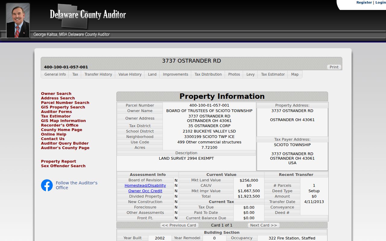
The field layout gives a street directory user a careful way to separate location, owner, correspondence, and parcel facts before checking another office.
Map a Scioto Township Street Before Deeds
The GIS is the map step in a Scioto Township address search, not a substitute for the Recorder. Its Property, Advanced, Subdivision, and Intersection search modes support address work. The configured viewer offers current and prior parcels, boundaries, utilities, zoning and development layers, plus imagery from 1997 through 2024. Selection, measure, draw, buffer, print, and snapshot tools add context, while results are capped at 1,000 graphics.
For a plat, the county GIS instructions say to open Layers, choose Boundaries and then Subdivisions, select the parcel, use the popup's layer selector when needed, and follow the linked Plat PDF. For a survey, turn on Points of Interest, choose Survey Points, click the S marker, switch the popup from parcel to survey, and follow its link. This documented path is particularly useful where a road name alone does not make the lot relationship clear.
- Parcel
- A defined piece of land in the county's property system, identified by a parcel number and mapped boundaries.
- Situs address
- The physical location attached to a parcel. It can differ from the tax correspondence address.
- Plat
- A recorded subdivision or land map. GIS can point to it, while the Recorder keeps the official recorded material.
- Criss-cross directory
- A historical reverse-address volume that may organize entries by location rather than by name. No complete Scioto Township run was verified.
Note: GIS mapping is public reference data, so confirm boundary or survey questions with the relevant recorded plat, survey, or qualified professional.
Scioto Township Roads on the Zoning Map
The 2025 township zoning map supplies real road context for a Scioto Township address search. It labels roads including Brown, Tyler, State Route 37 West, Slocum, Houseman, Degood, Burnt Pond, Carr, Ostrander, State Route 257 South, Fontanelle, Marysville, Klondike, Penn, Newhouse, Russell, Stover, Calhoun, Larcomb, and Mills. It also shows the Village of Ostrander, property lines and right-of-way, zoning districts, and the Scioto River.
The map is valuable for normalizing a road name or locating the right zoning district. It deliberately does not provide property ownership names. Take that location context back to the Auditor or Recorder for the owner or recorded-document question. No verified township-wide renumbering or renaming project was found, so an older address should never be treated as a simple modern street-number match.
Use the Scioto Township zoning materials for the map, certificate applications, driveway forms, variance material, fee schedule, and commission minutes.
Zoning records can date a site change or identify an administrative file, but they remain distinct from the parcel and deed trail.
Scioto Township Address Records by Custodian
Different Delaware County and Scioto Township offices hold different pieces of an address-record trail. The chain is strongest when each office is asked for the record it actually keeps. Auditor and GIS data establish the parcel setting; the Treasurer offers a second address route; the Recorder preserves conveyance instruments; and zoning or Building Safety can supply a targeted site-file route. Older material belongs at the Records Center or historical repositories, not in a claim that a modern search screen is complete.
| Address record | Custodian | What it contributes | Access route |
|---|---|---|---|
| Current parcel roll | County Auditor | Parcel, owner, situs, value, conveyance date, and mapped parcel. | Free property search and GIS. |
| Tax search | County Treasurer | Matching parcel by address, parcel, or owner surname. | One criterion at a time. |
| Deed or lien instrument | County Recorder | Recorded parties, instrument, volume/page, date, and official-copy route. | Web records from 1990 onward, then counter or archive. |
| Plat or survey | GIS and Recorder | Subdivision, map, and recorded survey connection. | GIS layers and popup links, then Recorder custody. |
| Certificate or permit file | Township zoning or Building Safety | Site, project, certificate, plan, or date when the file is public. | Address-specific request or office contact. |
| Historic transfer material | Cryder Library and Records Center | Older county property, maps, and transfer context. | Research counter, appointment, or defined request. |
The township is not a city government with a citywide permit index. For a defined address record, identify the address, parcel if known, approximate year, record type, and whether inspection or a copy is wanted. Ohio's Public Records Act directs a request to the office that has the record, rather than shifting it among county offices.
Scioto Township Recorder Trail After 1990
The Recorder's web collection is a key boundary in the Scioto Township address trail. Its official notice says real-estate documents from 1990 to the present are online. Earlier documents are in the Recorder's Office. Public Access accepts Name, Book/Page, and Instrument Number searches after its terms step; a free account is not required, though the portal recommends one for saved settings, history, and a document cart.
Use grantor and grantee roles for a deed, then carry forward the instrument number, volume/page, recording date, parcel or tract linkage, and legal description. Do not try to follow title by street name alone. Rural addresses, subdivision changes, reassigned addresses, and multi-parcel properties can make that shortcut wrong. The Recorder's own guidance also notes that image availability begins at different dates by document type and that not every post-1990 item was computerized.
For the pre-1990 handoff, use the Recorder exam room at 145 N. Union Street during weekday 8:30 to 4:30 hours, then the Delaware County Records Center for older county material. Ask for a legal description, parcel, book, film, or named party. The Records Center can help with specific inquiries, and Cryder Research Library's Mendenhall Files cover county property transfers from 1800 to 1891.
Note: Recorder AlertMe sends prospective recorded-document notices after enrollment, but it does not validate a document or replace a historical search.
Scioto Township Address Files Beyond Parcels
Scioto Township zoning creates a separate, address-linked administrative route. The published material includes zoning certificates, agricultural-exemption affidavits, conditional-use and variance applications, driveway permits, plot-plan guidance, a zoning code, a map, a fee schedule, and commission minutes. A certificate is required for structures and additions under the township's published information. That makes zoning a useful way to ask about a known project or historic site file.
No universal public online address-case index was verified. Start with the form and map to identify the right file type, then contact the zoning office for an address-specific historic record. Delaware County Building Safety is the related county route for building, plan-review, and inspection material in unincorporated territory. A name on an application or in a meeting minute is an administrative fact, not a finding that the person occupied the location.
Older Scioto Township Streets Need Maps
Scioto Township sits in Virginia Military Land, where older legal descriptions can follow irregular surveys, rivers, creeks, and tracts rather than a rectangular section grid. That geography is an important reason to retain the legal description with an address search. When a current road label fails in an older source, move outward from the present parcel and instrument to subdivision or survey context, county road books, historical atlases, directories, census records, and newspaper material.
The Records Center identifies county road record books from 1808 through 1941. The county map collection includes 1849, 1866, 1875, and 1908 atlases. The 1866 Scioto Township atlas is a dated landholder, road, farm, and advertising-directory source, not proof of a modern title. This evidence ladder avoids inventing a renumbering story where no verified road-renumbering record has been located.
Limits of a Scioto Township Street Directory
Address records have clear limits. Auditor and Recorder entries identify property roles and transactions, not every person at a site. The Ohio voter tool verifies a named individual's registration and precinct details; it is not a person-free street browser. DMV personal data, personal utility and delivery accounts, protected voter fields, Safe at Home information, sealed matters, and other protected information are not public street-directory results.
Ohio's menacing by stalking statute and telecommunications-harassment statute apply regardless of whether a fact appeared in a public index. Check any ambiguous address with the proper custodian before relying on it.